
Fencing, Enclave Disputes, and the Grand Mission to Secure the ‘Chicken’s Neck’….
Author: Colonel Dev Anand Lohamaror
(Expert in Security & International Affairs) ..
Following the birth of Bangladesh in 1971, a complex 4,096-kilometer border came into existence. To organize this frontier, the Land Boundary Agreement (LBA) was signed on May 16, 1974, and accepted in 1975. The greatest practical anomaly was the existence of 162 enclaves—111 Bangladeshi enclaves inside India and 51 Indian enclaves inside Bangladesh. These pockets became unmonitored havens for trafficking, smuggling, fake currency (FICN), and infiltration. To rectify this blunder, the Government of India executed a territorial exchange through the 100th Constitutional Amendment Act in 2015, permanently demarcating the boundary.
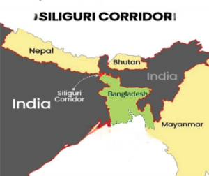
Today, this eastern frontier is undergoing a massive strategic realignment. The Siliguri Corridor (‘Chicken’s Neck’) and its adjoining border districts have moved to the center of India’s national security priorities. Following a clear mandate from the Ministry of Home Affairs (MHA) to the Border Security Force (BSF) to render the frontier completely impenetrable, tangible results are manifesting on Ground Zero. Yet, alongside intense local standoffs, a deeper trilateral geopolitical equation involving China, Pakistan, and a shifting Bangladeshi establishment is beginning to surface, threatening the balance of power in South Asia.
Heavy military tension was recently witnessed in the Cooch Behar sector of West Bengal, where an Indian revenue team (Amins), protected by the BSF, initiated a land survey and pillar-marking exercise to seal a vulnerable 27-kilometer porous patch near the Siliguri Corridor. This drive was disrupted by local Bangladeshi civilians, backed by armed personnel from the Border Guards Bangladesh (BGB). Cooch Behar shares a 500-kilometer border with Bangladesh, out of which a 50-kilometer segment has historically remained unfenced and porous, facilitating cross-border crime.
Situated here is the Dahagram-Angarpota enclave, the only major Bangladeshi territory remaining marooned inside India near the mouth of the Teesta River. It connects to mainland Bangladesh via a narrow strip of Indian territory measuring just 178 meters in length, known as the ‘Teen Bigha Corridor’, which India leased to Dhaka for administrative access. The crisis erupted when the Indian team established alignment pillars 50 feet inside sovereign territory from the Zero Point, drawing vehement protests from a BGB unit officer who claimed a 150-yard “No Construction Zone” barred the work. However, under international legal norms and the 1974–75 agreements, this restriction applies strictly to permanent defense structures like tactical bunkers or military outposts, not protective infrastructure. Since barbed wire fencing is universally classified as a non-permanent, defensive measure designed for crime prevention rather than military aggression, India retains an absolute sovereign right to secure its territory right up to the border line.
Despite the historic success of the 2015 LBA, the physical execution of barbed wire fencing on the ground continues to confront immense human and sociological challenges. If border engineers blindly execute the fencing at a rigid, mathematical distance of exactly 150 yards inside Indian territory from the zero line, entire segments of inhabited Indian border villages and vast agricultural fields end up stranded on the wrong side of the fence—marooned in a legal no-man’s-land between the high-security fence and the actual international border. The human realities of these border populations are deeply intertwined; for generations, the local lifestyle has been fluid, with families sharing deep cross-border ties where individuals routinely have dinner on one side of the border and cross the open fields for agricultural harvesting on the other side the following morning.
Therefore, the current border infrastructure drive cannot be treated as a cold, mechanical engineering project or a purely military exercise. It has evolved into a highly sensitive, deeply complex Socio-Political Mission. The Indian state is forced to constantly balance national security imperatives with human empathy—managing complex land acquisition processes, providing massive financial compensation, and organizing alternative agricultural land for displaced border citizens. Nevertheless, as history shows, when the state demonstrates absolute firmness, deploys the full weight of its administrative machinery, and enforces clear security protocols, the work gets done seamlessly.
While India aggressively consolidates its internal territorial sovereignty, a highly coordinated, dangerous tactical alignment is rapidly taking shape just beyond its eastern frontiers. The upcoming state visit of Pakistan Prime Minister Shehbaz Sharif and Air Force delegations to Dhaka, timed in precise synchronization with the Bangladeshi political leadership’s (Tariq Rahman) upcoming high-stakes state visit to Beijing, represents a calculated, trilateral strategic chess move rather than routine regional diplomacy. This emerging axis between Islamabad and Dhaka has entered the realm of active operational military cooperation.
High-level military delegations from both nations are currently finalizing agreements centered on the advanced sourcing of military hardware—with Bangladesh in active discussions to procure the joint Chinese-Pakistani JF-17 Thunder fighter jets to replace its aging fleet—alongside tactical training interoperability for advanced combat pilot programs, and deep technology transfers for joint drone manufacturing and short-range missile production aimed at rapidly modernizing Bangladesh’s domestic defense industrial complex. Concurrently, Beijing is aggressively expanding its strategic footprint through the funding and execution of the massive Teesta River Comprehensive Management Project. This mega-infrastructure development sits directly adjacent to the Siliguri Corridor, establishing a forward listening post where New Delhi can least afford a hostile Chinese intelligence, surveillance, and reconnaissance presence.
The desks of senior policymakers within India’s South Block—housing the Ministry of External Affairs (MEA) and the Ministry of Defence (MoD)—are currently flooded with urgent, highly classified intelligence files detailing this coordinated triple-threat. The convergence of Pakistani Air Force delegations in Dhaka, massive Chinese state-backed infrastructure investments near chokepoints, and the sudden reactivation of sleeper Islamist networks in the border districts are landing on the same desk at the exact same time. Sealing a physical border against illegal infiltration is a tactical border management problem; responding to a well-calibrated, three-way strategic encirclement designed to choke India’s access to its Northeast is an entirely different, highly complex geopolitical ballgame.
New Delhi is currently executing an incredibly intricate, sophisticated border policy defined by a dual doctrine: “Tough at the border, Warm at the table.” On one hand, the government’s core political constituency demands absolute, visible toughness on the ground—characterized by the unyielding deployment of smart fences, zero tolerance for BGB provocations, and the systematic identification and deportation of every single illegal infiltrator. On the other hand, the broader geopolitical matrix requires India to maintain a high degree of diplomatic warmth and engagement at the bilateral table.
New Delhi must continue to offer substantive cooperative initiatives, economic partnerships, and mutually agreeable frameworks—such as keeping the Teesta water-sharing resolution actively on the table—to the new political dispensation in Dhaka. This is essential to provide Bangladesh with a viable alternative, preventing it from drifting permanently and irreversibly into the hostile China-Pakistan military axis. Striking this delicate, high-stakes balance between military deterrence on the frontier and sophisticated diplomacy in the capital will ultimately dictate the national security architecture and geopolitical future of South Asia for decades to come.


